Oh, Wyoming! We had no idea what staggering wonders you hold within your borders. Yes, there are the Grand Tetons. Yes, there is Yellowstone (whose size alone is utterly incomprehensible—and which will get more coverage in another post, I promise). But there is so much more.
We left Yellowstone at deep dusk with fifty miles to go before we reached Cody, our destination for the night.
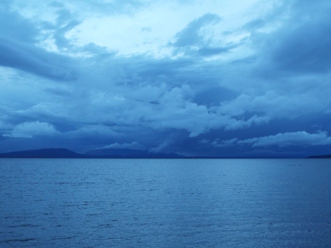
Yellowstone Lake at dusk
We didn’t know Cody was named for Buffalo Bill or that he was its founder back in 1896. It was just a convenient stopping point. Neither did we know the road we were traveling has been called the fifty most beautiful miles in America—by none other than Teddy Roosevelt. We’ll have to take his word for it; we could barely see a thing in the foggy dark. But we saw enough to believe that a daytime trip through the wilderness of the Shoshone National Forest in the Wapiti Valley with the Shoshone River running alongside the road might be almost too beautiful to bear.
In the morning light, we realized Cody itself might have given us a fun day of adventure, but we had many miles to go before we could rest our heads on pillows that night—Wyoming is one big state! Along the way we passed Thermopolis, which lays claim to the world’s largest mineral hot springs. Wish we’d had time for one of its promised free soaks, courtesy of Hot Springs State Park.
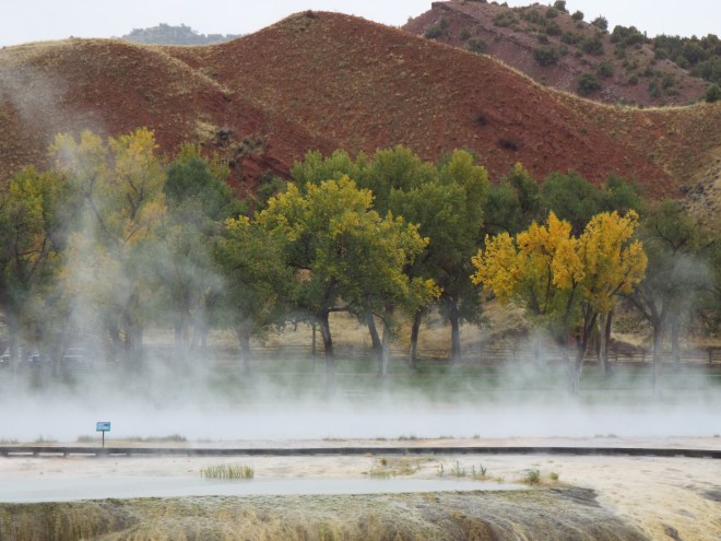
Steam rising from Thermopolis’ hot springs
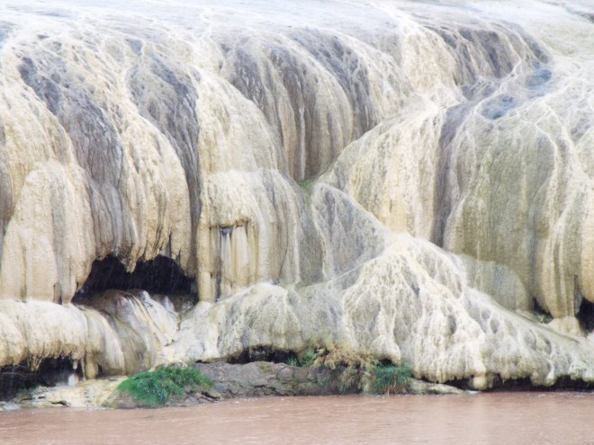
Hot Springs mineral deposits.
And then it happened. We were already in it before we realized we were actually inside a canyon, heading for its floor. We were floored as we drove into and out of Wind River Canyon, which was full of signs like this first one we saw, each pointing out a little slice of geologic time.
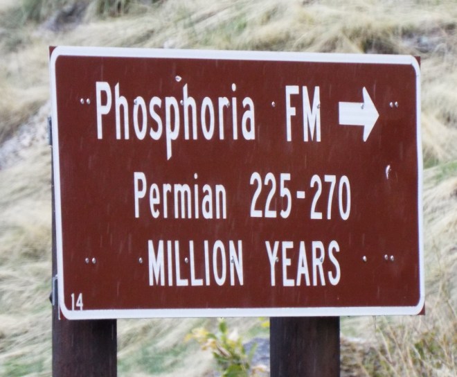
Phosphoria Formation from the Permian Period
These signs accompanied us all the way to the canyon floor’s Precambrian era, 2500 feet deep and 2.5 to 3 billion years into prehistory. We were time traveling, y’all!


And another cool thing: as we entered the canyon from its north end, the river’s name changed—from the Wind to the Bighorn. The spot where the change occurs has its own name: Wedding of the Waters. Don’t you just love it? The river, of course, flows through the bottom of the canyon walls. When we entered the canyon from above, it was far, far below us. As we descended, it seemed to rise until we were almost level with it.  The canyon with its high rock walls, rapidly flowing river, and railroad running on a narrow ledge between the river and the canyon wall caught us completely off guard. And it became one of the two biggest highlights (other than family, of course) of our entire trip. All in thirty-four miles. They say you can drive it in forty minutes if you don’t stop. But of course we did. We wanted to savor it—both the scenery and the sheer awesomeness of the experience.
Honestly, I don’t know how we ever got to our next destination, the little town of Douglas, population 6,120. Just as with Cody, we’d planned to spend the night in Douglas only because the timing was right to get us where we wanted to go the next day. But Douglas was full of its own treats.
Douglas: home of the jackalope. You know, that mythical half-rabbit, half antelope creature you grew up hearing about? Well, Douglas is where it all started. Legends abound. Like its ability to mimic human voices, or that it mates only when lightning flashes, or its fondness for whiskey. The Chamber of Commerce even dispenses licenses for hunting the rare creature, legal only from midnight to 2:00 am on June 31st. 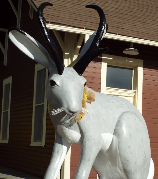 Douglas is full of history. Established in 1867 when Fort Fetterman was built just ten miles away, named for Stephen A. Douglas (Lincoln’s presidential opponent), a World War II prisoner of war camp that held 5,000 German and Italian soldiers, and home to both the Wyoming Pioneer Memorial Museum and the Wyoming State Fair.
 Our Douglas lodging was the charming Hotel LaBonte, currently on the National Register of Historic Places. It’s hard not to let your imagination run wild when you stand in the lobby. The place reeks of ranchers, cattle barons, and railroad tycoons.
 Just as it was closing time, we dropped in on what may be the world’s friendliest Chamber of Commerce where the helpful staff told us about what turned out to be the other biggest highlight of our trip: the Oregon Trail Ruts and Register Cliff, part of the Oregon National Historic Trail. We’d been planning on turning in early, but it didn’t take a nanosecond for us to change our plans and take off for Guernsey, just twenty miles away.
The whole of the Oregon Trail was over 2,000 miles long, beginning in Independence, Missouri, and ending in Oregon’s Willamette Valley. From there, pioneers chose between settling down or spreading out, going either north or south. Most heavily used from 1841-1869, almost half a million people traveled it.
The routes varied somewhat from one wagon train to another, but not here. Because of the topography, almost all of the nearly 500,000 westward-heading folks traveled this very same path near Guernsey with their horses and wagons or their handcarts. Not just to Oregon—this passage was part of the Mormon, California, and Santa Fe Trails, too. In places, their feet, wheels, and hooves wore the sandstone rock down to a depth of five or six feet, still visible today. Imagine!

See the top of these rocks? That’s the level the first pioneers traveled. Four hundred thousand plus people with their horses and wagons and carts wore the rock down this much.
 Just a couple of miles away is a place called Register Cliff. Think of it as a pioneer version of a hotel and its accompanying ledger. The sandstone cliff, in those times a day’s journey from their previous night’s stay at Fort Laramie, provided some degree of shelter as well as a place where people could chisel their names and date of arrival. Maybe it was a message to relatives and friends coming in a later caravan. Or maybe it was a way of recording for the ages, “Look, I made it this far!”
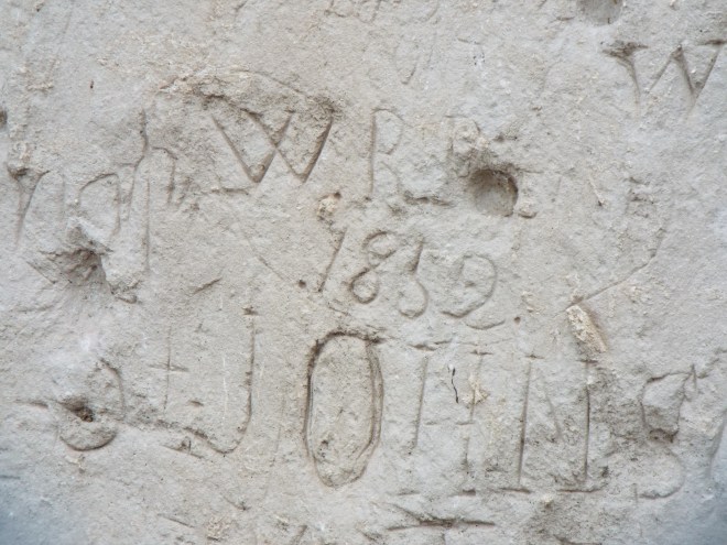

What were their fates?
Now, I’ve just got to take a minute here to tell you this was a deeply spiritual experience for me. I felt that I was on sacred ground. Not that it’s personal—my ancestors traveled no farther west than east Tennessee in their search for land and a brighter tomorrow. But they did cross the Atlantic in dangerously rickety boats to face the unknown, knowing they’d never see beloved faces and familiar places again. And some of them did trek across the mountains from Pennsylvania to Virginia to Tennessee to western North Carolina in a time when roads were scarce and hazards were plenty. That particular history and struggle is part of me and I feel it deep in the core of my being. So, seeing these ruts and the names of some of the people who made them moved me.
The Oregon Ruts and Register Cliff touched me in a way I cannot express. If you get a chance, you really should see them. Give yourself time to study the signage, time to examine the names faintly etched into the rock. Time to “see” these people. Time to think on things. Things bigger than yourself. Here is a place where you can immerse yourself in the story, a story of heroism and hope. And a place where you can actually touch history.
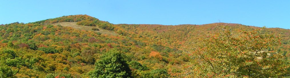
Oh, by the way, those clouds that were missing earlier in our trip? We found ’em. Wyoming, you stirred my soul and stole my heart.
(More of Our Grand Road Trip still to come. Stay tuned. Want to read about our trip from the beginning? Start here.)

Pingback: Our Grand Road Trip, Part VI: The Touristy Things – Living on the Diagonal
Thanks for the tip, Leslie. Always looking for a good read. Will definitely add those to my list.
LikeLike
After reading this wonderful overview of the Wyoming portion of your adventure, I think you would enjoy reading the 1859 book The Prairie Traveler, a Handbook for Overland Expeditions (Kindle version is 99 cents) and also Ox-Team Days on the Oregon Trail (Kindle version 99 cents).
LikeLiked by 1 person
Thanks for the tip, Leslie. Always looking for a good read. Definitely picking these up from Kindle.
LikeLike